Seasonal weather continues for the second week of December
9:15 a.m., Mon, Dec 8, 2014 - We seem to be locked in a stable weather pattern. This week, our weather will be mostly dry with a fair amount of sunshine expected. Our temps are forecast to be slightly above normal by the weekend.
The only concern is for Thursday night and what affects, if any, we'll receive from an East Coast storm, although any issues will probably be limited to northeast Ohio.
Later today, we'll receive some rain with a chance for freezing rain after Midnight.
Normal Toledo temps for this week are highs in the upper 30s and lows in the mid 20s.
Excerpts from this morning's area forecast discussion, issued by the Cleveland NWS:
Tonight:
Thursday Night:
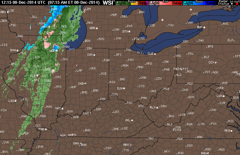
Radar loop ending at 9:15 a.m.
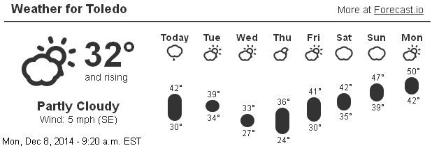
TOL Forecast
Toledo 7-day forecast
Last Update: Dec 8, 2014 6:40 am
Today: A chance of rain, mainly after 3pm. Cloudy, with a high near 42. South wind 9 to 11 mph. Chance of precipitation is 40%. New precipitation amounts of less than a tenth of an inch possible.
Tonight: Rain likely before 9pm, then rain and snow likely between 9pm and 11pm, then a chance of rain after 11pm. Cloudy, with a low around 32. South wind 5 to 9 mph becoming calm after midnight. Chance of precipitation is 70%. Little or no snow accumulation expected.
Tuesday: A chance of rain and snow showers. Cloudy, with a high near 39. North wind 6 to 11 mph. Chance of precipitation is 30%. Little or no snow accumulation expected.
Tuesday Night: A slight chance of snow showers before midnight. Cloudy, with a low around 29. North wind 11 to 14 mph. Chance of precipitation is 20%.
Wednesday: Partly sunny, with a high near 33. North wind around 11 mph.
Wednesday Night: Partly cloudy, with a low around 24.
Thursday: Partly sunny, with a high near 36.
Thursday Night: Mostly cloudy, with a low around 29.
Friday: Partly sunny, with a high near 39.
Friday Night: Mostly cloudy, with a low around 31.
Saturday: Partly sunny, with a high near 42.
Saturday Night: Mostly cloudy, with a low around 32.
Sunday: Partly sunny, with a high near 46.
Area Forecast Discussion
fxus61 kcle 081406
afdcle
area forecast discussion
national weather service cleveland oh
906 am est mon dec 8 2014
synopsis...
a clipper system will slide southeast across the great lakes
region between today and tonight then merge with a stronger east
coast storm on tuesday. the east coast storm will then have an
influence/impact on the local area through the end of the week.
high pressure is likely by the weekend.
&&
near term /until 6 pm this evening/...
a shortwave over the upper midwest will move across the great
lakes region today and aid in digging a deep trough across the
eastern u.s. for mid week. a weak clipper will reach the local area
this evening/tonight and bring light precipitation. precip could
arrive in the far west toward 6 pm but temps will be warm enough for
just rain. an abundance of cloud cover will stick around today as
high clouds are replaced by mid level clouds. temperatures will be
warmer than yesterday by a handful of degrees...seasonable. went
with a blend of guidance.
&&
short term /6 pm this evening through thursday night/...
the weak front occluded by this time will cross the area tonight.
meanwhile the upper trough will be overhead and it will begin to
influence the development of the system on the east coast. will
begin with the best precip chances across the west half of the
area this evening...but then reduce but linger chances across all
of the area for the remainder of the night. as far as precip type
goes...narrow corridor of better moisture with the front will
yield a rain/snow mix...but in its wake moisture shallower and
transition precip to rain or drizzle with temperatures falling
into the lower 30s. will keep temps right at or above freezing
for lows tonight for most. freezing drizzle would be a possibility
if temperatures do reach or drop below 32 degrees late tonight.
the system on the east coast will influence our weather through
thursday night. will still be watching details closely.
differences amongst the models in how low the upper low lingers
across new york/new england and to what degree moisture rotates
back into our area.
precip chances linger on tuesday with cyclonic flow. flow will
become more nnw with time tuesday...but the colder air aloft for
any lake effect is slow to arrive. will highlight the colder temps
aloft and possibly the arrival of deeper moisture rotating around
the upper low to the east with an increase in pops for wednesday
into thursday...primarily across the snowbelt. across the
west...high pressure will be in waiting across mo/il/in. with the
trend colder...may be able to see some accumulating snow for the
snowbelt wednesday night and thursday...but the lake influence
remains marginal. there will be signs that the pesky upper low
will begin to pull away thursday night.
&&
long term /friday through sunday/...
the high amplitude pattern will likely linger into the end of the
week and the consensus is for a somewhat slower movement to the
upper low compared to the gfs...but not as slow as the operational
ecmwf. cannot rule out lingering snow showers/flurries...mainly in
the snowbelt...on friday.
there may remain various amounts of mid and high clouds into the
weekend as differential advection increases. temperatures should
creep back above normal especially by sunday although the flow may
remain rather light so it may not get as warm as it could. will
forecast highs in the 40s.
&&
aviation /12z monday through friday/...
increasing south southeast flow ahead of a cold front today. vfr
conditions will continue into evening with mid/high clouds. as the
front begins to cross the area tonight ceilings and visibilities
will drop to mvfr with ifr ceilings developing after the frontal
passage. it will take quite a while for the front to make it from
ktol to keri as the upper trough deepens overhead.
outlook...non vfr likely tuesday in rain/snow showers. non-vfr
mainly in northeast ohio and northwest pennsylvania tue night
into thur with lingering snow showers.
&&
marine...
will let the small craft advisory expire this morning. winds will
continue to veer more from the southeast and south as the surface
high pressure moves east. the southeast to south winds will be
brisk...15 to 20 knots...but the larger waves will remain well
offshore and conditions will remain below small craft criteria today
as long as one stays close to the south shore.
the next cold front is expected on tuesday. the front will likely be
slow to move across the lake. the upper trough is deepening and
cutting off...so despite the nearness of the day 2 forecast...not a
lot of confidence in the timing of the front as winds will shift
from south to north northwest.
the north winds will pick up as a coastal low develops and a small
craft advisory will be needed again by tuesday night and likely
remain in effect through thursday... especially east of the islands.
&&
cle watches/warnings/advisories...
oh...none.
pa...none.
marine...none.
&&
$$
synopsis...oudeman
near term...oudeman/adams
short term...oudeman
long term...kosarik
aviation...kosarik
marine...kosarik
by testuser
- 1273 words
- 7 min read
created:
- modified:
- #
source
-
versions
- related posts